


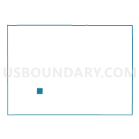
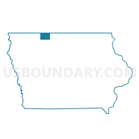
WALLINGFORD Voting District, Emmet County, Iowa
About
Outline

Summary
| Unique Area Identifier | 582077 |
| Name | WALLINGFORD Voting District |
| County | Emmet County |
| State | Iowa |
| Area (square miles) | 0.97 |
| Land Area (square miles) | 0.97 |
| Water Area (square miles) | 0.00 |
| % of Land Area | 100.00 |
| % of Water Area | 0.00 |
| Latitude of the Internal Point | 43.32015510 |
| Longtitude of the Internal Point | -94.79242750 |
Maps

Graphs
Select a template below for downloading or customizing gragh for WALLINGFORD Voting District, Emmet County, Iowa


Neighbors
Neighoring Voting District (by Name) Neighboring Voting District on the Map
- HIGH LAKE TWP W/O WALLINGFORD Voting District, Emmet County, IA
- TWELVE MILE LAKE TWP W/O WALLINGFORD Voting District, Emmet County, IA